The Met Office has issued a ‘stay indoors’ warning ahead of the arrival of Storm Eunice on Friday, which is forecast to bring snow and strong winds of up to 100mph in northern England.
After it was reported earlier this week that the UK was to be hit by two storms within three days, which would bring strong winds, heavy rain showers, and even some snow and ‘blizzard conditions’, Storm Dudley arrived on Tuesday night into Wednesday, and left thousands of homes without power across the north and Scotland, and also caused travel chaos on roads and train lines.
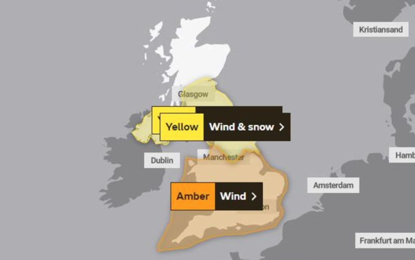
Yellow weather alerts with an amber warnings were put in place for the two events.
Now, after a brief respite on Thursday, people are being warned to prepare for even worse weather as Storm Eunice moves in and threatens “significant disruption” for much of the UK.
As well as advising people to stay indoors if possible, the Met Office has also issued a “danger to life” amber warning which covers all of the north, and widespread parts of England for tomorrow, and unfortunately, there’s also warnings of further power outages and disruption to transport services as well.
More than 14,000 people suffered power outages, and travel was disrupted by uprooted trees across the UK following winds of more than 80mph during Storm Dudley.
ADVERTISEMENT
Looking ahead to #StormEunice on Friday, we are expecting to see even more dangerous weather conditions moving in 💨
“Yellow and amber warnings for wind have been issued for Storm Eunice, which is going to impact much of the UK on Friday,” the Met Office confirmed in a statement.
“The most significant wind gusts are expected in the south and west of the UK, with an amber warning now in force here from the early hours of Friday morning.
“Inland areas could see gusts to around 80mph, bringing the potential for fallen trees, damage to buildings and travel disruption [and] although Storm Eunice’s strongest winds will be on its southern edge, the northern flank of the system brings the potential for some snow to northern areas.
ADVERTISEMENT
“A yellow warning for wind and snow has been issued covering Northern Ireland, northern England and southern Scotland, where potentially up to 20cm of snow could accumulate over high ground, with up to 5cm possible in some lower areas.
“Brisk winds in this area could cause blizzard-like conditions and drifting of lying snow, reducing visibility, and making driving conditions difficult.”
The Met Office has issued a ‘danger to life’ amber warning for tomorrow / Credit: Met Office
Explaining the impact Storm Eunice is likely the have and the reason for its arrival, Frank Saunders – Chief Meteorologist at the Met Office – said: “An active jet stream is helping to drive low-pressure systems across the country.
“Significant disruption is possible from Storm Eunice, with strong winds one of the main themes of the current forecast.
“Storm Eunice is expected to track eastwards from early on Friday, bringing the most significant winds to the central and southern areas of the UK, with some gusts possible in excess of 95mph in exposed coastal areas.”
ADVERTISEMENT
Storm Eunice’s amber warning for northern England begins at 3am on Friday and lasts until 9pm, and a snow warning in northern areas is in place from 3am until 6pm the same day.
Manchester Metropolitan University announce landmark partnership with MCR Basketball
Danny Jones
Manchester Metropolitan University (MMU) and Manchester Basketball have detailed a renewed and landmark partnership that looks set to nurture the next generation of talent.
Joining forces with MMU, this is not only the latest effort by MCR Basketball to further invest in young players and grassroots sports here in Manchester, but yet another example of further education creating viable routes into the game for their sporting stars of the future.
While the two organisations already boast an established relationship, this next step in their continued teamwork should prove even more fruitful for both parties, as the still only recently relaunched local basketball side looks to raise its profile in the city.
Confirming their intent to further intertwine their youth development setup and plans to innovate pathways for players, representatives from both met to confirm the announcement this week.
🤝 New partnership to drive basketball innovation & develop future talent. @ManMetUni & Manchester Basketball have announced a new strategic partnership to advance research, education and development of basketball to inspire the next generation of talent. #RepTheCity
With existing coaching staff already working between the two and both of the male and female training camps based over at Platt Lane Sports Complex, it only feels like a natural fit.
Moreover, this increased collaboration between the two is also a promising prospect for MMU Sport, specifically, meaning much more than just the sharing of facilities at the likes of Platt Lane over in Fallowfield and the National Basketball Performance Centre at Belle Vue.
As well as pooled resources, this will also crucially create potential opportunities for those at the uni or preparing to graduate, including student internships and more.
Claire Bradbury, Manchester Basketball CEO, said in an official statement: “As basketball in Manchester enters a new era, we’re excited to formalise our partnership with Manchester Metropolitan University.
“This is a true collaboration bringing together elite, professional basketball and leading academic sports expertise to create opportunities that support the development of players, staff and students.
Together we are investing in the future of basketball to grow the game in our region and working to establish the city of Manchester and Manchester Basketball as one of the leading basketball hubs in Europe.”
Man Met are looking pitch-perfect for the region’s leading ‘college ball’ feeder club, to use more American terminology, already.
Laura Hickman-Sparkes, MMU’s Head of Business Engagement and Partnerships at the Institute of Sport, went on to say: “Basketball is entering an incredibly exciting period, with growing participation, investment and visibility across Europe.”
For example, as well as the Super League Finals having been held at the AO Arena, the city is also most notably hosting a regular season NBA fixture at Co-op Live – a historic moment, to say the least.
“We’re delighted to be partnering with Manchester Basketball at such an important time and look forward to creating opportunities for our students”, she adds, “supporting innovation through research and helping to grow the game across Manchester and beyond.”
In other MMU Sport-related news, their very own ‘Visiting Professor’, who has only just retired from the professional circuit, is also set to fly the flag for the institution and disabled athletes across the country.
Featured Images — Publicity pictures (supplied via Manchester Basketball/Peter Simmons)
News
New Prime Minister Andy Burnham announces VAT cuts on household electricity bills over winter
Emily Sergeant
It’s been less than 24 hours since Andy Burnham officially became Prime Minister, and he’s already announced his first measure.
After giving his first speech as Prime Minister outside the doors of Number 10 yesterday, where he said he intended to ‘give people some breathing space’ straight out the gate, it has now been announced that millions of households across the UK will benefit from immediate action to help with their electricity bills this winter.
The Government says it wants to address the cost of living crisis first and foremost, and will do this by tackling rising bills with a tax cut to remove VAT from domestic electricity bills from 1 October, just in time to impact the next Ofgem price cap.
This immediate action applies and is funded for this financial year.
The cost of this immediate action for this financial year is being funded from the £1.8bn Digital ID programme – which Burnham also announced he would be scrapping.
Any further action – including on funding for longer-term measures – will be taken at the Budget, alongside an Office for Budget Responsibility (OBR) forecast, and all decisions at that point will continue to be funded with the Government’s fiscal rules, it has been confirmed.
Cutting VAT on electricity bills is expected to take around £45 off the yearly Ofgem price cap in October, and this is on top of the £150 removed from bills at the last Budget.
All suppliers are expected to pass the VAT reduction on to all customers, including those on fixed tariffs.
Small businesses who qualify for the domestic energy VAT relief and are not registered for VAT, as well as charities and residential care homes eligible for the reduced rate, will also benefit.
“I said I wanted to give people breathing space, and that’s what I’m announcing on my second day as Prime Minister. We’re taking immediate action to cut taxes on energy bills, put more money in people’s pockets, and bring back hope.”