Brace yourselves: ANOTHER heatwave is set to hit the UK – the fourth in 2026 so far – and, understandably, Greater Manchester residents are already preparing for the latest blast of hot weather and wondering when it gets here.
Yes, in case you missed the news, more high temperatures are set to spread across Great Britain and Ireland this month and heading into August.
The increase will gradually build throughout this week, with Wednesday tipped to be the hottest day according to various meteorological sources.
Fortunately for us here in the North West, parts of the Midlands and the usual suspects down south are set to hit the highest numbers, but the thermometers are still on course to reach around the mid-20s over the coming days.
Temperatures are set to rise this week across some areas, bringing a return to hotter conditions 🥵
The heat looks to be fairly short-lived, however, with temperatures expected to fall again towards the end of the week 🌡️ pic.twitter.com/IKsunEdwhU
Estimates of 26°C have been predicted for this coming Tuesday, with the levels floating in and around 24/25 on the following Wednesday.
The heat is then due to drop off slowly, with top scores of no higher than 21°C on the cards for Thursday and Friday. Although the weekend forecast is less certain at present, one thing that has been announced is reduced rainfall.
ADVERTISEMENT
Aside from a few more trickles today (Mon, 27 July), the showers or lack thereof cease rather soon, with some of the driest parts of the country already having various effects; for instance, parched parts of Wales have even revealed lost archaeological sites last Friday (24/7/2026).
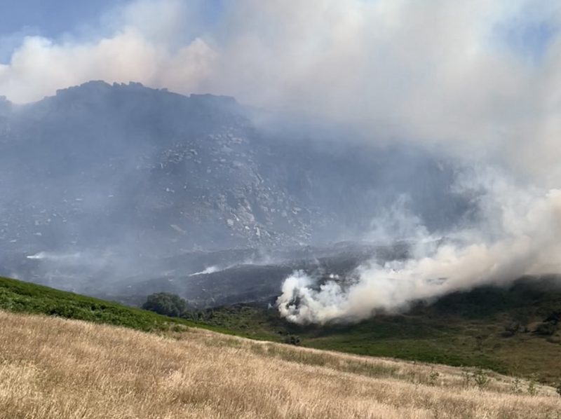
It would be remiss if we didn’t mention the obvious moorland fires across our region, which were sadly exacerbated by hot weather earlier this month.
Following on from the hottest June on record, the Dovestone and Tinwhistle areas of Oldham and parts of Derbyshire saw hundreds of hectares turn into a deeply dangerous blaze for several days.
ADVERTISEMENT
As per the latest statistics, it’s said that the equivalent of 1,250 football pitches were scorched following the alarming wildfire, which also raised concerns for wildlife and surrounding air quality.
Met Office gives verdict on how Storm Boelo aftermath will affect Greater Manchester this week
Emily Sergeant
Storm Boelo is finally on his way out, and now the Met Office has given its verdict on what we can expect from the rest of the week.
In the aftermath of two successive storms, Storm Austen followed by Storm Boelo – the latter of which affected Greater Manchester – the UK is now able to begin recovering from the effects of the adverse weather.
But the Met Office has warned that, although there is no named storm, strong winds and heavy rain will continue to affect parts of the UK early this week, before high pressure brings calmer conditions.
Yellow national severe weather warnings are in place for parts of Scotland and western areas of the UK today (Tuesday 27 October), including areas of the North West, as gales and spells of rain bring the potential for ongoing disruption around the region, particularly on exposed coasts and higher ground.
“The continued winds could hamper recovery efforts in some places,” forecasters also unfortunately confirmed.
⚠️ Strong winds and heavy rain continue across parts of the UK early this week with a yellow weather warning in place, before high pressure brings calmer conditions for many from Wednesday ⛅
Read our news release to find out more 👇
https://t.co/EQU4vvaA3B https://t.co/hpvTd8v7EZ
As rest of the week pans out though, conditions will begin to settle down and showers are expected to become ‘less frequent’, while winds also ease for most, although gales could continue for a time in the far north.
Thursday is expected be ‘largely dry’ with lighter winds and variable cloud, with a touch of mist and fog likely across parts of England and Wales during the morning.
From Friday and into the weekend, light rain will team up to potentially affect northwestern areas of England, but for the most part, temperatures are expected to remain close to, or slightly above, average for the time of year.
“From Wednesday, high pressure will start to build which will ease the winds and bring a quieter and largely drier end to the week for many, although some rain is still possible in the North and West,” explained Met Office Deputy Chief Forecaster, Steven Keates.
“However, with wind warnings in place, those in warnings areas, particularly in northern Scotland and western high ground, continue to be exposed to strong winds and heavy rain before the more settled weather arrives.”
Featured Image – The Manc Group
Weather
UK set to be battered by storms as ‘unprecedented’ El Niño arrives this autumn
Emily Sergeant
The UK is being told to brace for a series of storms this autumn when the ‘unprecedented’ El Niño weather event arrives.
It’s already been a summer of extremes for the country, with multiple heatwaves over the past couple of months, but now it appears that autumn and winter are set to have some extremes of their own, as the Met Office is warning that this upcoming El Niño could be one of the most significant in recent memory.
El Niño is declared when sea temperatures in the tropical eastern Pacific rise 0.5°C above the long-term average, which therefore impacts global rainfall patterns and average temperatures.
The natural warming of sea temperatures is forecast to reach more than 3°C in the coming months, according to the Met Office, making this year’s weather event have the potential to be ‘the largest since the 19th century’.
The UK is set to be battered by storms as ‘unprecedented’ El Niño arrives this autumn / Credit: Johannes Plenio (via Unsplash)
El Niño will create a heightened risk of drought in the tropics, southern Africa, and north eastern Australia, but over in north western Europe – including the UK – it means we are likely to experience wetter and stormier conditions.
The UK, and of course Greater Manchester, is absolutely no stranger to a storm around this time of year, but forecasters say this could be an entirely different beast.
“We should be clear that this is an unprecedented event,” warned Professor Adam Scaife, who is the Head of Long Range Forecasting at the Met Office.
“I have never seen an El Nino signal this intense in our forecasts.”
Professor Scaife concluded: “A typical El Nino leads to an equatorial Pacific sea-surface temperature rise of between one to 2°C, with 2°C being a really big event. This implies that, if the forecast is accurate, and other forecast systems show similar extreme values, then 2026 will far exceed our recent experience of El Niño and its worldwide climate influences.’
Forecasters and officials, however, have warned that it could take months of sustained rainfall before rivers, reservoirs, and groundwaters are ‘completely replenished’ – which is when a drought can officially be declared as over.
It also warned drought conditions could persist into the new year as, despite El Niño, as current forecasts do not suggest this autumn will have the amount of rainfall needed to drive recovery.

 Danny Jones -
27th July 2026