Forecasters are predicting that a unique weather phenomenon known as ‘thundersnow’ could be on its way to us over the next few days.
We saw all manner of unpredictable weather conditions at the latter end of 2021, with both Storm Arwen and Storm Barra gracing us with their presence, all before the country experienced what was described as “an exceptionally mild spell” and recorded the warmest ever New Year’s Day since records began.
But the start of 2022 already sounds like it’s giving 2021 a run for its money.
You may have already heard – and probably felt – that temperatures have plummeted this week and that the Met Office has issued a yellow weather warning for snow and ice for much of the North, including parts of Greater Manchester, from between 10am-11am today (Thursday 6 January) right through to 10am tomorrow.
The weather warnings put in place by the Met Office appear to cover parts of Bolton, Bury, Rochdale, Oldham, and Wigan.
ADVERTISEMENT
Lancashire, West Yorkshire, Cumbria, Scotland, and Ireland are all included too.
Across the two days, forecasters are saying there could be “frequent sleet and snow showers” leading to some potential disruption to travel and difficult driving conditions, and the Met Office says that some roads and railways are likely to be affected, with longer journey times by road, bus, and train services
There will also probably be some icy patches on untreated roads, pavements, and cycle paths, and in some places, potentially a few brief power outages are possible too, with a risk of isolated lightning strikes.
That’s not all though, as now, apparently some ‘thundersnow’ is on its way too.
ADVERTISEMENT
What is ‘thundersnow’?
It’s not a term you hear very often, but according to the Met Office, this unique weather phenomenon occurs when thunderstorms form in wintery conditions and release heavy downpours of snow, and when this is then paired with the usual thunder and lighting, this creates ‘thundersnow’.
Usually only occurring a few times a year, it is driven by the same conditions that cause thunderstorms in the summer.
The only difference is, it’s winter – and of course, there’s snow.
The Met Office says: “The snow contained within the thunderstorm acts to dampen the sound of the thunder [and] while the thunder from a typical thunderstorm might be heard many miles away, the thunder during a thundersnow event will only be heard if you are within 2 to 3 miles of the lightning.”
On top of that, the falling snow can even make lightning strikes look brighter as the flash reflects off the snowflakes.
ADVERTISEMENT
The Met Office has issued a yellow weather warning for snow and ice for much of the North / Credit: Wikimedia Commons
What are forecasters saying?
Grahame Madge – Spokesperson for the Met Office – explained: “At the moment we’ve got a ridge of high pressure leading to clear skies.
“Into the early hours of tomorrow morning, we’ll start to see a weather front approach from the west, bearing in mind conditions will have been intensely cold overnight with frost and freezing fog in southern parts of England.
“We’ll get this frontal band of precipitation working east, then as that cold air bumps into the weather front moving in we’ll see a line of snow along that front.”
He said ‘thundersnow’ would be caused by the difference between the cold front arriving from the west, reaching the ground that has been warmed by unseasonable temperatures, and then once again, he added that the conditions were driven by the same meteorological conditions as storms in summer.
Mr Madge added that ‘thundersnow’ can sound “distinct”, as it is muffled by snow.
An innovative new Macbeth stage production is being put on at an unlikely venue in Oldham
Danny Jones
A brand-new innovative take on Macbeth is coming to a rather surprising venue in Oldham as part of a new production by the Coliseum.
It may be BY Oldham Coliseum Theatre, but this new stage show is taking place at a rather different kind of location entirely.
Teaming up with North West actor Nick Bagnall and director, who has already served in an associate role at the Liverpool Everyman and Playhouse, this will be his very first production, and unlike most other Shakespeare performances you will have come across.
With his various plays serving as ever-perfect pairings for adaptation, his version of arguably the world’s most famous tragedy is coming to an iconic site in its own right, which just so happens to be a nightclub.
Yes, Nick Bagnall and Oldham Coliseum Theatre‘s twist on Macbeth will be coming to none other than Liquid and Envy on Retiro Street.
A legendary local institution known for more late-night entertainment, the native artist is using it as a staging ground for a very unique interpretation.
While this version will still revolve around the same themes of ambition, masculinity, power and identity, it will instead be set against a late-1970s backdrop, in a world filled with gangsters, casinos and similarly shifting social codes.
Perhaps not as contemporary as current modern-day (we’ve seen plenty of that even in the past couple of decades alone), but it still looks set to be a creative take on the timeless tale; a retelling of Romeo and Juliet is also part of their autumn/winter programme.
Speaking ahead of the debut, Nick said picking Macbeth was a no-brainer. “Macbeth asks profound questions about power, identity and what it means to be a man,” he said. “Those questions feel urgent in a proud industrial town like Oldham that is navigating huge social and economic change.
“I want to blow the dust off Shakespeare. This isn’t about putting the play on a pedestal; it’s about creating an experience that grabs people by the throat, whether they have seen Macbeth ten times or never encountered it before.
“We want people who have never set foot in a theatre to walk into Liquid & Envy and feel this story belongs to them. Staging Macbeth inside a working Oldham nightclub creates its own intrigue.”
Martina Murphy, Chief Executive of Oldham Coliseum Theatre, went on to add: “This is a huge moment for the Coliseum. Nick’s Macbeth is uncompromising, thrilling and unmistakably of this place, and it announces exactly the kind of theatre we intend to make.
“As we continue our journey back to Fairbottom Street, we are determined to keep creating ambitious work that surprises audiences and reaches people wherever they are. Macbeth demonstrates that the Coliseum isn’t waiting for its building to return before making theatre of national significance.”
Check out the full list of scheduled performances set to arrive later this year:
Macbeth at Liquid and Envy in Oldham – 2026 dates
October
Friday 23 – 1:30pm (preview)
Saturday 24 – 1:30pm and 6:30pm (previews)
Monday 26 – 7pm (preview)
Tuesday 27 – 7pm (press night)
Wednesday 28 – 7pm
Thursday 29 – 1:30pm and 7pm
Friday 30 – 6:30pm
Saturday 31 – 1:30pm and 6:30pm
November
Monday 2 – 7pm
Tuesday, 3 – 1:30pm and 7pm
Wednesday, 4 – 7pm
Thursday, 5 – 1:30pm and 7pm
Friday, 6 – 6:30pm
Saturday, 7 – 6:30pm
It’s also worth noting that these shows have been put together with accessibility in mind, with the two-week season including a relaxed performance, an audio-described version, a fully captioned version, as well as two interpreted with British Sign Language. Things we love to hear.
The Coliseum’s new Creative Director has also ensured that tickets remain affordable, with £15 concessions and preview passes costing just £20, as well as a discount for Oldham locals.
You can see the full list of ticket options and find out more information about this exciting production right HERE.
Safe to say that we can’t wait to see how this thing turns out. It’s not the only inventive theatrical take on a classic that’s coming to Greater Manchester later this year, either; find out more down below.
Featured Images — Publicity pictures (supplied/Nick Bagnall (via Instagram)
Trending
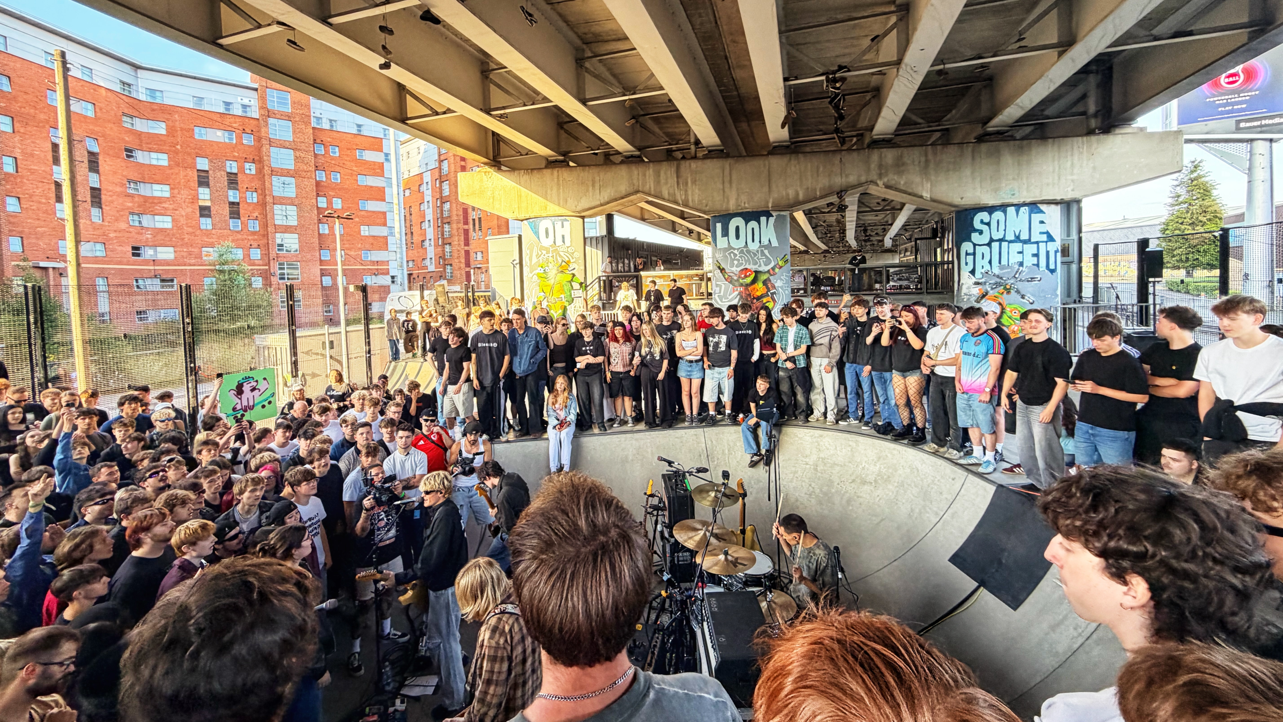
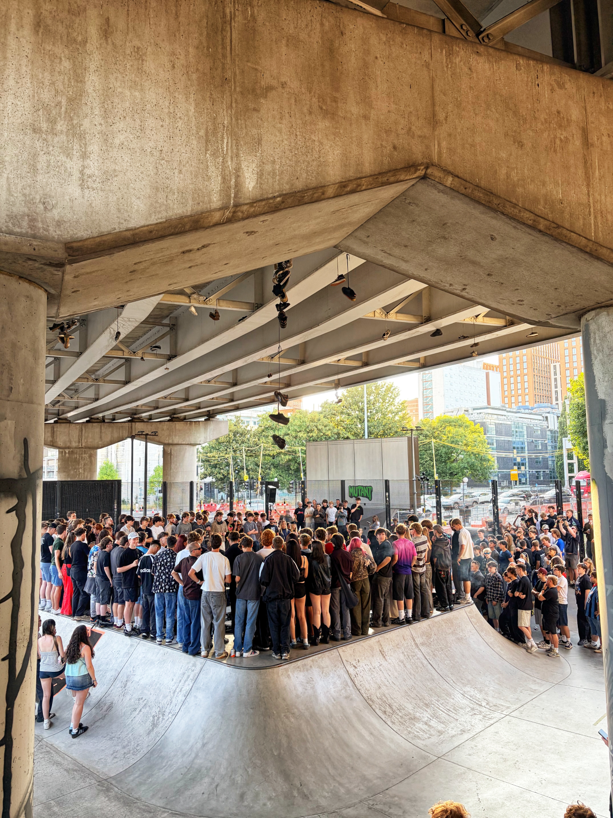
Keo play Projekts: garage and grunge revivalists crush Manchester skatepark for new music video
Danny Jones
This past Thursday evening, fast-rising rock band Keo took over Projekts MCR skatepark for a special pop-up gig and to film a brand-new music video for their latest single, ‘Pistol’, starring some of their biggest fans here in Manchester.
In fact, it didn’t take long for us to suss out that plenty of them had flocked from far and wide to be there, and let’s say we’re sure they’ll say it was worth the journey.
We caught Keo’s well-attended festival set inside the Woodlands at Kendal Calling 2025, not to mention their completely sold-out show at the O2 Ritz back in March – their biggest headline date up to that point – and we’re more certain than ever that they’re going to be absolutely massive.
And if they keep up doing more memorable stuff like this, it’s just a matter of how soon…
Packing out Projekts to the point that people were literally hanging off fences and standing on electrical boxes at the side of the street to try and get a peek at the post-punk, grunge and garage rockers, some of their most enthusiastic young fans had been waiting outside the location as early as noon.
For context, doors opened six hours later, and the boys didn’t come on until 7:30pm.
Those who signed up to Keo‘s mailing list were sent information regarding securing a spot at the one-off performance earlier this month.
While you would have seen the place fill up even if they were just standard concert tickets, the fact that the band were taping the whole thing to use as the visuals for their newest single, as mentioned, meant that Keo’s avid followers were literally clamouring AND clambering to get the best view position possible.
Turning the popular skaters’ hub’s central bowl into a makeshift stage, with lights, camera, booms and various crew surrounding the entire venue, it was a surreal experience to say the least.
And, of course, they were absolutely brilliant – just as they were at the Ritz at the start of the year and Kendal before that, playing a short but sweet set that left everyone wanting more and choruses of punters chanting Keo long after the final song.
We can’t wait to see how the video itself turns out, especially seeing how much the people who wrapped around them and the skatepark were lost in the moment, and we’re also looking forward to them headlining Neighbourhood Fest in Manchester city centre this October.
You can grab a ticket to see them and the rest of the NBHD lineup right HERE, but until then, give the full studio version of ‘Pistol’ a play and get ready for their debut album.