The Stalybridge areas of Millbrook and Carrbrook were the most affected by the incident – however, it was luckily confirmed from the police’s initial enquiries, as well as from the updates provided by partnering emergency services at the North West Ambulance Service (NWAS) and Greater Manchester Fire and Rescue Service (GMFRS) who also attended, that there have thankfully been no injuries reported.
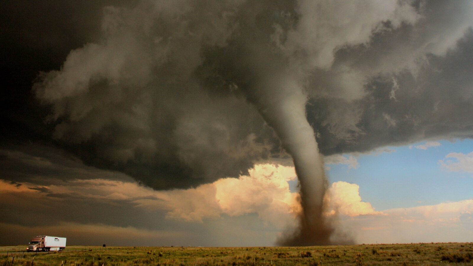
#UPDATE | At around 11.45pm yesterday evening (Wednesday 27 December 2023), Greater Manchester Police (GMP) were called to numerous reports of significant damage to various properties across Stalybridge in Tameside.
Temporary shelter and support services are currently being provided for the displaced and affected residents by Tameside Council.
ADVERTISEMENT
GMP is advising that anyone affected should keep a close eye on and monitor Tameside Council’s social media for advice and guidance, or call 0161 342 2222 where Council representatives will be on hand to offer support.
While this damaging weather event was initially described as being a “localised tornado”, Met Office meteorologists have referred to it as a ‘supercell thunderstorm’ at this point, and say they know from their Dopplar radar that it had a strong rotating updraft.
ADVERTISEMENT
Experts are still waiting for surface data to confirm, but have admitted that the presence of these features “suggests a tornado at the surface was likely”.
Last night a supercell thunderstorm crossed Greater Manchester causing damage. We know from our Dopplar radar that it had a strong rotating updraft. Whilst we don't yet have surface data to confirm, the presence of these features suggests a tornado at the surface was likely 🌪️ pic.twitter.com/XEG1TkKbjN
But what exactly is a ‘supercell thunderstorm’ then? Why does it occur? And how does it differ from the regular thunderstorm we’re all used to?
Well, the answer is all in the tornado.
ADVERTISEMENT
What is a tornado?
The Met Office defines a tornado as a “swirling column of air” that spins rapidly with winds of over 40mph or 60kph.
Described by weather experts as being one of the most violent and dramatic weather types on the planet, which serve as a demonstration of the “destructive power of our turbulent atmosphere”, there are several different types of tornado – with the fastest wind speeds ever recorded for a tornado being over 300mph or 480kph.
Not only are they the fastest wind speeds ever recorded for a tornado, they are actually the fastest winds ever recorded on Earth, according to the Met Office.
How is a tornado formed?
Tornadoes form in “very unsettled weather conditions” as part of severe thunderstorms, according to experts at the Met Office.
A tornado typically has the form of a twisting funnel-shaped cloud between the cloud base and the ground. Sometimes the vortex can appear as a slender rope-like form, particularly when the tornado is weakening, although sometimes a tornado can be almost invisible, and is only observable by the debris thrown up from the surface.
ADVERTISEMENT
Tornadoes usually form from big thunderstorms called ‘supercells’ – which was the case for the incident last night in Stalybridge – but can form from other types of storms too, with tropical cyclones being one of the most common.
Tornadoes form in “very unsettled weather conditions” as part of severe thunderstorms / Credit: Met Office
How is a ‘supercell thunderstorm’ different to a regular thunderstorm?
A thunderstorm is defined by the Met Office as a series of sudden electrical discharges that result from atmospheric conditions.
Most thunderstorms are associated with towering clouds known as cumulonimbus, and the right conditions for the formation of a thunderstorm are unstable air and a mechanism for causing air to rise – which is usually hot and humid air, with lots of energy.
When a thunderstorm is being fed lots of warm and moist air, it continues to grow and can begin to rotate, and then, if this rotation begins to lower from the cloud, a tornado begins to form – however, at this stage, it’s just called a ‘funnel cloud’.
It’s only when the funnel reaches the ground that becomes a tornado.
Featured Image – Tameside Council
News
Andy Burnham explains why Number 10 North is so important as it officially ‘opens for business’
Emily Sergeant
Andy Burnham has explained his key reasons for launching Number 10 North as it officially ‘opens for business’ this week.
You may remember that earlier last month, Andy Burnham revealed he had intentions to create a Number 10 North if he was to become Prime Minister, with the new base expected to be a ‘dominant driver of the UK’s economy’ once it was officially up and running… and now, fast forward to today, Number 10 North is officially ‘open for business’.
Operating from Heron House in Manchester city centre, as previously reported on, Number 10 North will be the Government’s new ‘situation room for growth’.
It also brings the ‘levers’ of local economic growth and devolution together under one roof for the first time ever.
Number 10 North has officially ‘opened for business’ / Credit: gov.uk (via Wikimedia Commons)
With the Prime Minister expected to work from Number 10 North each week, so that decisions about the country’s economic future will no longer exclusively be made in Westminster, and with other ministers also working from there on a regular basis, the Government says the move underlines its determination to ‘do things differently’.
Now that Number 10 North has officially opened, Andy Burnham and his fellow ministers have explained why this move is so important for not just Manchester, but the north as a whole.
“For 40 years, power and resources have been sucked into the centre, and too many communities have felt forgotten, without the attention and investment they deserve,” explained Andy Burnham.
“Number 10 North will change that by putting more power into every postcode across the entire country. It will be the situation room for making Britain better, the place we use to get power out of Westminster, into the hands of people at a local level, so that they can turn things around.
“The days of Whitehall resisting devolution are over, for good.”
First Secretary Louise Haigh added: “Today marks a fundamental re-balancing of where power sits in our country. Number 10 North has been set up to drive economic growth in every postcode and put power in the hands of every community.
“Through this department, this Government will ensure that the places overlooked by Westminster for decades are given a real voice.
“Number 10 North is open for business.”
Featured Image – The Manc Group
News
Scissors, toy guns, and baseball bat among 100+ items confiscated by security at Manchester Airport
Emily Sergeant
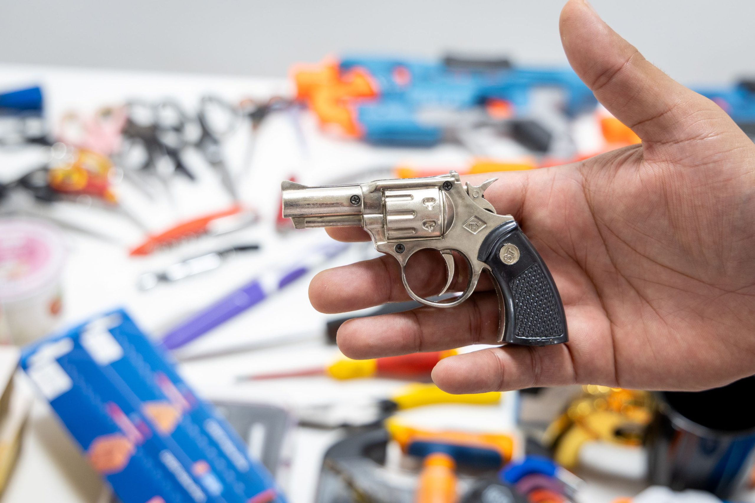
Manchester Airport has revealed a shocking list over 100 items confiscated by security staff in just one morning.
And honestly, you won’t believe some of the things people have tried to take on a plane.
With schools across Greater Manchester having now broken up for the summer holidays, and families getting ready to jet off on their holidays, Manchester Airport is urging all passengers travelling over the next six weeks to make sure they know the hand luggage rules before boarding the plane, after more than 100 items recently had to be confiscated by security in one morning alone.
12 pairs of scissors, 10 toy guns, seven corkscrews, four knives, two loose chisels, a pair of pliers, and even a baseball bat were among the items forming part of the shocking confiscation haul.
On top of this, security also confiscated dozens of cosmetic products, drinks bottles, and food items like multipacks of yoghurts.
Scissors, toy guns, and a baseball bat are among 100+ items confiscated by security at Manchester Airport / Credit: Manchester Airport
Although new 3D scanning technology has been installed at both of Manchester Airport’s terminals now, making the process smoother overall, those travelling during the busy summer period are reminded that attempting to bring non-compliant items through airport security causes delays for themselves and for others.
Airport security bosses are encouraging people to reacquaint themselves with the rules for hand luggage before packing for their journey.
“We’re proud of the role we play in getting people’s journeys off to the right start, and more than 97% of our passengers are getting through security checks in under 15 minutes,” commented Sakib Mahmood, who is the Security Duty Manager for T2 at Manchester Airport
All if these items were confiscated in just one morning / Credit: Manchester Airport
“But each time we have to pull a bag aside for a manual search it can take several minutes, and that can quickly start to add up and create delays.
“The range of items confiscated here in just a few hours shows what our security officers are up against every day, but when it comes to working out what is restricted and what is not, we know some items are more obvious than others.
“If you take a moment to reacquaint yourself with the rules before packing your hand luggage, it can save you lots of time when you get to Security, and avoids you losing items like water guns or bottles of suncream that you want to take on your holiday with you.
“In many cases, items like these which may fall foul of hand luggage restrictions can be taken in your hold luggage, so if in any doubt, pack the item in your suitcase rather than your carry-on bag.”