If you saw footage of a ‘mini tornado’ ripping through Manchester online this past weekend, no, your eyes weren’t deceiving you: it did happen and, turns out, it’s a pretty strange and rare phenomenon– at least in this part of the world.
They say 0161 has everything but a beach, and now we seemingly have little twisters of our own, they might just have a point.
In all seriousness, footage went viral on social media, being met with equal surprise and alarm as most were understandably confused at how this could even happen in the UK, given our climate isn’t typically used to these kinds of weather events.
For those of you who haven’t seen it already, here’s what it looked like…
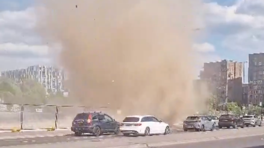
Did you see the mini Manc tornado that passed through Ancoats last weekend? 🌪️
We’ll admit that when first heard a so-called tornado had been spotted in Manchester, we pictured a little spiral of leaves and crisps packets in a supermarket car park, but as you can see, it really was much more significant than that.
ADVERTISEMENT
Reported as having towered as high as 30 metres along Great Ancoats Street, various people saw the startling city centre sight and quickly began querying what the hell they were seeing online.
Despite many dubbing it a tornado, we can confirm it was something slightly different.
ADVERTISEMENT
What caused the ‘Manchester tornado’?
What you’re looking at is what is colloquially known as a ‘dust devil’; put simply, these are small, rotating columns of air that pick up dust and debris from the ground and obviously resemble a tornado at times, especially when they manage to become as wide and tall as this one did.
As explained by the Met Office, “A dust devil forms due to irregularities caused by temperature contrasts on different surfaces, which then causes rotation of the air and, when there’s dust and debris, you can get these columns of air.”
Here’s another angle:
ADVERTISEMENT
WATCH: MASSIVE Dust Devil in Manchester, England yesterday!#tornado
We don’t need to tell you that it’s been pretty warm of late (bloody gorgeous, in fact) and, as a result, the chances of creating a proper dust devil are much greater than usual.
The Met Office went on to add: “Unlike tornadoes, dust devils grow upwards from the ground, rather than down from clouds. In the stronger dust devils, a cumulus cloud can be seen at the top of the rising column of warm air.
“They only last a few minutes because cool air is sucked into the base of the rising vortex, cooling the ground and cutting off its heat supply.”
It’s not the only strange meteorological event seen around Greater Manchester recently, either. From the likes of ‘supercell thunderstorm’ and the eerily silent ‘heat lightning’ in late 2023, to the UFO-like swirl seen across various parts of the globe earlier this year.
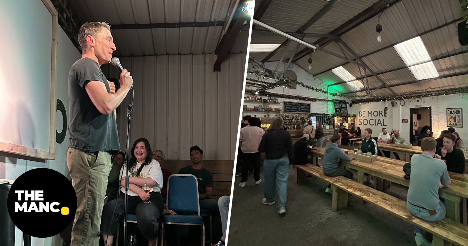
Pat Regan at the Fairfield Social Club – a brilliantly unhinged evening of standup comedy
Clementine Hall
There’s a particular kind of chaos that only Pat Regan can deliver, and the recently re-recognised Fairfield Social Club got the full force of it last night.
Making his Manchester debut as part of the ‘A Lovely Time’ series at the equally as lovely Fairfield Social Club, the New York comic, writer, and podcast host arrived with the energy of someone who had already lived through three emotional breakdowns before breakfast and somehow still had the worst to come.
Known for his work on HBO’s Hacks and the cult-favourite podcast Seek Treatment with fellow comic Catherine Cohen, Regan’s stand-up feels less like your traditional comedy set and more like being trapped in the world’s funniest group chat.
The perfectly intimate room beneath Fairfield’s railway arches was packed with adoring fans who were immediately on side as Regan launched into stories about traumatic trips to Paris, Grindr dates, massage tables and having crushes at the gym.
The audience was in the palm of his slightly sweaty hands (don’t worry, he’ll be fine with me saying so), laughing at every awkward punchline and self-deprecating anecdote.
The material is nothing groundbreaking, but this is what makes it so deeply hilarious; never before has shopping for the perfect pair of jeans been so serious and unserious at the same time.
There was laughter rolling through the venue for virtually the entire set, and after an hour of never-ending quips and jokes, we were left wanting more.
And the best part is, it won’t be long until we get more from this place, and it’s no wonder they’re starting to get the hosting plaudits they deserve.
It’s safe to say Fairfield Social Club has become one of Manchester’s most exciting homes for alternative comedy, and this felt like exactly the sort of booking that justifies its growing reputation.
By the time Regan left the stage, the audience looked equal parts exhausted and delighted. An absolutely classy evening indeed.
Find out about what else is on at the Fairfield Social Club HERE.
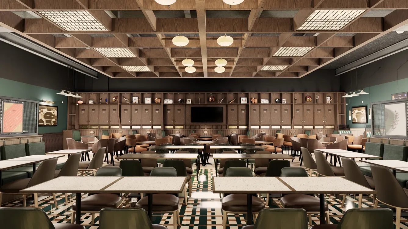
First-ever JD Wetherspoon pub to open at Manchester Airport
Danny Jones
In news that we feel many Mancs and travellers all-round have been waiting on for a long time, the well-known British chain, JD Wetherspoon, will be opening its first-ever pub at Manchester Airport.
That’s right: soon that first airport pint of the holiday could actually be a relatively cheap one.
While Wetherspoons are no strangers to popping up in terminals across the UK and Ireland, they’ve never done so here in Manchester despite having three, yes THREE, in Gatwick alone.
Not for much longer, though, as soon T2 will be lending more than 3,000 square feet of its prime leisure and retail real estate to a new Greater Manchester ‘Spoons’.
Posting on social media, the airport wrote: “Wetherspoon comes to Manchester Airport this September! The pub will be located in the Terminal 2 Departures lounge and will have more than 300 seats.
“This will become the final major food and drink venue to open its doors as part of our decade-long £1.3bn transformation of Terminal 2. It will be named ‘The Belle Vue’, in a nod to Manchester’s historic showground [now a sports complex and leisure hub].
“It was a focal point for social life in the city from the Victorian period up until 2020, when the final event was held at Belle Vue stadium. The design of the pub is inspired by the history of Belle Vue and the sporting culture of the North West of England. We look forward to welcoming you all in September!”
While a lot of money has been pumped into T2’s refurb as a whole over the past few years, it remains unclear just how much this particular new addition will cost; we do know that great sums were set aside for the launch of the Great Northern Market last year.
The inaugural Manchester Airport Spoons is just the latest in a series of major renovations.
As mentioned, the company already operate several up and down the country – 10 airport pubs, to be specific – but this will be the first in the North West.
Speaking on the news, JD Wetherspoon chief executive John Hutson said in a statement: “We are looking forward to opening at Manchester Airport. We believe our new pub will prove popular with travellers of all ages and be an asset to the new terminal.”
With Manchester Airport adding a dozen new routes to its roster this summer, you can expect to see even more people flying in and out than ever – no doubt having already polished off a cut-price pint or two beforehand.